
-
Research Article
-
A Study on the Design Criteria and Method of High Height Multi-Tiered MSE Walls
고성토 다단식 보강토옹벽의 설계기준 및 설계법에 관한 고찰
-
Byung-Il Kim, Sang-Jae Han, Young-Tae Seo, Tae-Hyung Kim
김병일, 한상재, 서영태, 김태형
- As the construction of large-scale industrial complexes progresses, the need for MSE walls, such as large-scale cut or high fill, is gradually …
대규모 산업단지 조성 등을 위해 대절토나 고성토 보강토옹벽이 필요한 경우 다단 형태로 설계 및 시공되는 사례가 점진적으로 늘어나고 있지만, 국내 설계기준은 외국의 …
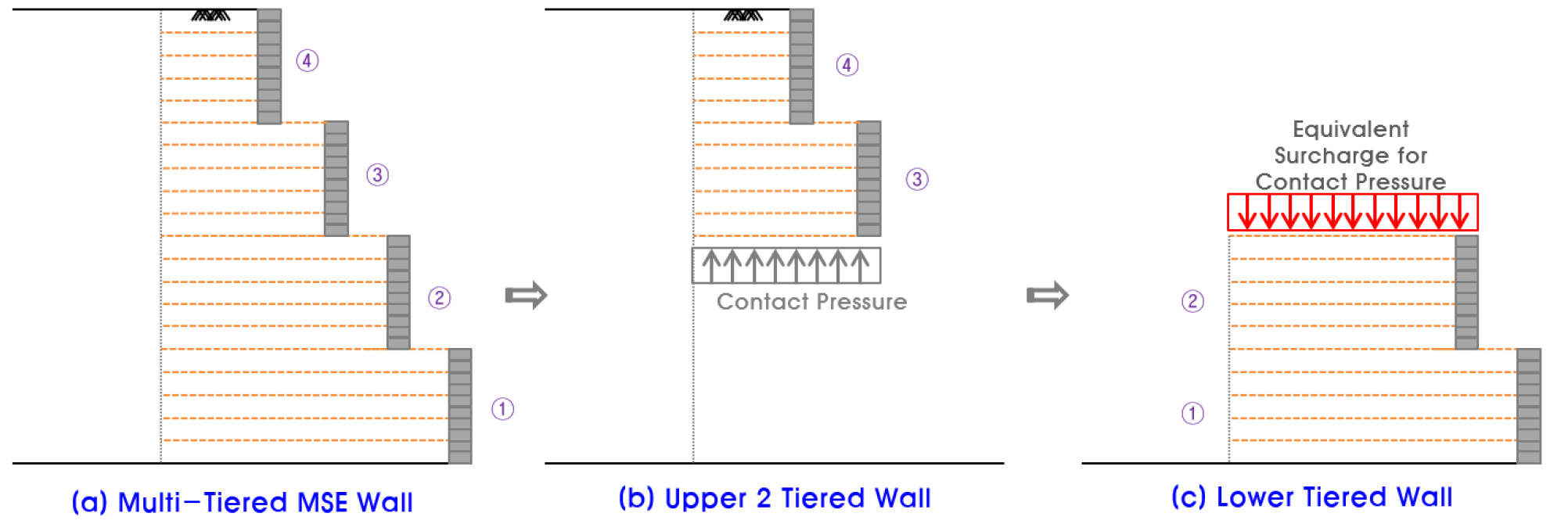
- As the construction of large-scale industrial complexes progresses, the need for MSE walls, such as large-scale cut or high fill, is gradually increasing, often being designed and constructed in multi-tiered forms. However, Korea design standards(KDS) largely rely on foreign criteria. This paper analyzes and discusses the design, construction, and numerical analysis of multi-tiered MSE walls in Korea, comparing domestic and international design standards and methods. The study indicates that a part of the domestic design standards requires improvement. The failure of high fill multi-tiered MSE walls follows a bi-linear pattern that passes through the active wedge failure within the backfill and directly beneath the reinforced soil, necessitating stability evaluation of planar compound sliding. It was found that for high embankments where deformation occurs due to fill, the safety factors derived from strength reduction analysis and limit equilibrium analysis differ. In finite element and limit equilibrium analysis of MSE walls with geosynthetics, the interface factor between the reinforcement and soil should apply the contact friction angle rather than the pullout angle. Additionally, the stability of compound sliding and the sliding pattern between extensible and non-extensible reinforcements in multi-tiered MSE walls differs, indicating a need for research on the limit height of walls, design methods, and related safety factors based on the type of reinforcement.
- COLLAPSE
대규모 산업단지 조성 등을 위해 대절토나 고성토 보강토옹벽이 필요한 경우 다단 형태로 설계 및 시공되는 사례가 점진적으로 늘어나고 있지만, 국내 설계기준은 외국의 기준을 상당 부분 그대로 적용하고 있는 실정이다. 이에 본 논문에서는 국내에서의 고성토 다단식 보강토옹벽에 대한 설계, 시공 및 수치해석 등을 통해 설계기준과 설계법에 대하여 분석 및 고찰하였다. 본 연구를 통해 국내 설계기준의 경우 일부 항목에 대하여 개선이 필요함을 알 수 있었다. 고성토 다단식 보강토옹벽의 파괴는 배면내 주동파괴선과 보강토체 직하부를 통과하는 2중 직선형태를 띠므로 직선활동에 대한 안정성 검토가 요구되고, 신장성 보강재를 사용하여 성토에 따른 변형이 발생되는 고성토의 경우 강도감소해석법과 한계평형해석법의 안전율이 상이함을 알 수 있었다. 전면포설형 토목섬유를 사용하는 보강토옹벽의 한계평형해석과 유한요소해석 시 보강재와 흙간의 접촉면에 대한 Interface Factor는 인발저항각이 아닌 접촉마찰각이 적용되어야 하고, 고성토 다단식 보강토옹벽의 경우 신장성 보강재와 비신장성 보강재의 변형 형태와 복합 활동 안정성도 상이하므로 보강재의 종류에 따른 옹벽의 한계 높이, 설계법 및 관련 기준 안전율에 대한 연구가 필요한 것으로 나타났다.
-
A Study on the Design Criteria and Method of High Height Multi-Tiered MSE Walls

Journal Informaiton
 Journal of the Korean Geosynthetics Society
Journal of the Korean Geosynthetics Society


한국지반신소재학회
#1003, Hyundai Hyel, 213-12 Saechang-ro, Yongsan-gu, Seoul 04376, Korea
Tel: +82-2-583-2167 / Fax: +82-2-3295-2168 / E-mail: kgss-adm@kgss.or.kr Copyright© Korean Geosythetics Society. Powered by APUB
Tel: +82-2-583-2167 / Fax: +82-2-3295-2168 / E-mail: kgss-adm@kgss.or.kr Copyright© Korean Geosythetics Society. Powered by APUB